Licensed under CC BY 4.0 by EUMETSAT
Documentation

Global Sea-Ice Concentration Interim Climate Data Record (SSMIS), release 3

Suspended since 17/10/2025 (input data missing). Please use OSI-438 Climate product

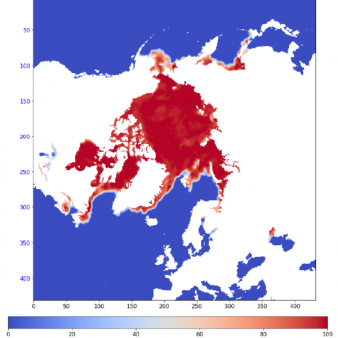
The sea-ice concentration Interim Climate Data Record covering the northern and southern hemispheres. Associated to the Climate Data Record OSI-450-a1.
L3/L4 daily files, and monthly average files, and monthly sea-ice extent/area indicator.
This product has two types of files; the nominal ICDR files with latency of 16 days, and so-called fast-track ICDR files with latency of 2 days, the latest being only available on the FTP server. The fast-track ICDR files for day D are replaced by the nominal ICDR files for the same day D when the nominal are produced at day D+16.

Identification
Acronym : GBL SICO ICDR R3
EUMETSAT collection ref. :

EO:EUM:DAT:0645

OSI SAF producer : Norwegian Meteorological Institute
Identifier : OSI-430-a (complementing OSI-450-a1)
Digital object identifier (DOI) 10.15770/EUM_SAF_OSI_0014
Id for archive (APNM) : OR430ASICO
Licence/Attribution/Citation : CC BY 4.0 See below
Characteristics
Processing level : L3+L4
Satellite input : DMSP/SSMIS from EUMETCast
Other input : NWP outputs (Copernicus C3S ERA5T, with ECMWF operational forecast as backup)
Temporal sampling : 24 h for the L3/L4 daily files. Monthly for the monthly files and indicator.
Central time : 12:00
Timeliness : ? The timeliness is the time elapsing from the sensing time of the last contributing file to the product dissemination to users. It is similar to the latency. 16 days
Spatial coverage : Global
Spatial sampling : 25 km
Projection : EASE2
File Format(s) : NetCDF4
Characteristics & methods : Daily averaged fractional ice cover in percentage.
Includes per-grid cell uncertainties.
Fully consistent with OSI-450-a, to ensure homogeneity.
Monthly averaged fractional ice cover are also distributed, as well as monthly sea-ice extent/area indicator.
Data Access

OSI SAF FTP server

ftp://osisaf.met.no/reprocessed/

Directory: conc-cont-reproc/v3p0

EUMETSAT Archive

EUMETSAT Online Map Service

Redistribution by Copernicus Marine Service

Redistribution by Copernicus Climate Change Service

Accuracy Requirements
Target accuracy : 8 % (yearly average)
Verification/validation method : Primary Method: Direct comparison against high-quality 0% and 100% SIC reference data (stemming from the ESA CCI projects, Pedersen et al. 2019). See additional methods in the comments at the bottom of this page.
Applications and users
Usage : Climate models, NWP and Ocean/Ice re-analyses, environmental agencies
History
Authorised to be operational / released :
Declared operational / released since :
On FTP server since :
First date :
Last date :
Full series temporal coverage : 2021-2025
Detailed history :

An ICDR complement each version of the Global Sea Ice Concentration Climate Data Record:

[1st release] OSI-430 complemented OSI-409 and OSI-409-a on the period from 16/04/2015 to 31/12/2019

[2nd release] OSI-430-b complemented OSI-450 on the period from 01/01/2016 to 30/04/2023

[3rd release] OSI-430-a complements OSI-450-a1 on the period from 01/01/2021 onwards. We advise you to use the latest release.

Suspended on 17/10/2025 because of the unstable access to SSMIS data. The long gaps in input data are indeed impacting the temporal consistency of this climate product. We advise all users to switch to the equivalent AMSR2-based climate data product (OSI-438).

Licence/Attribution/Citation
Licence : CC BY 4.0
Attribution : You must include attribution to EUMETSAT OSI SAF
Recommended citation : EUMETSAT OSI SAF, Global sea ice concentration interim climate data record (SSMIS) (v3.0, 2022), OSI-430-a, doi:10.15770/EUM_SAF_OSI_0014
References : BibteX entry
Comments
  • Verification/validation methods:

    • Primary Method: Direct comparison against high-quality 0% and 100% SIC reference data (stemming from the ESA CCI projects, Pedersen et al. 2019).
    • Additional: Comparison of SIC to US National Ice Center charts, to document the temporal consistency since 1979 (but limited by the low consistency of ice charts).
    • Additional: Comparison of Monthly Sea Ice Extent and Area time series with those of the US NSIDC Sea Ice Index (absolute level, departure from climatology, trend).
    • Additional : An evaluation of the uncertainties will be performed (at 0 % and 100 %, similar to in Lavergne et al., 2019). The traceability to SI units will be investigated.


New ticket helpdesk
CAPTCHA