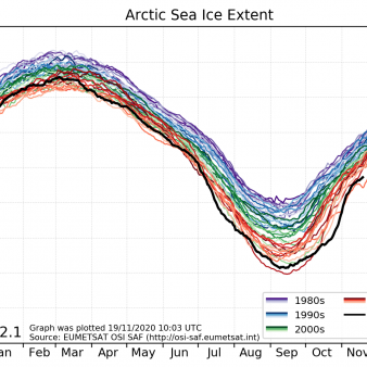
Sea-ice index
Demonstrational : we invite users to give feedback on the index before we make it operational. Climate productThe Sea Ice Index is a climate indicator of sea-ice coverage. The index covers both the sea-ice extent and area over the last 40+ years and is continuously updated to present time. It consists of an updated series of graphs (.png) visualising the trends and evolution of sea ice at hemispheric, global and regional scales. In addition, the data files (.txt and .nc) are available for users who are interested in analysing and plotting the data themselves. The Sea Ice Index is derived from the OSI SAF Global Sea Ice Concentration data, with R&D input from ESA CCI.
Identification
Acronym : SII
Product navigator reference :
EO:EUM:DAT:0875
OSI SAF producer : Norwegian Meteorological Institute
Identifier : OSI-420
Digital object identifier (DOI) 10.15770/EUM_SAF_OSI_0022
Acronym for EDC (APNM) : SIIN
License/Attribution : See at bottom
Characteristics
Processing level : Indicator
Satellite input : SMMR, DMSP/SSM/I, DMSP/SSMIS
Temporal sampling : Updated daily
Spatial coverage : Hemispherical and regional
File Formats : HL FTP Server (NetCDF4)
Data Access
OSI SAF FTP server
ftp://osisaf.met.no/prod_test/
Directory: ice/index/v2p2
OSI SAF Thredds
Applications and users
Usage : Climate
History
On FTP server since :
First date :
Full series temporal coverage : 1978-onwards
Detailed history :
v2.1 on the FTP server since 19/11/2020
v2.2 on the FTP server since 06/2023
License/Attribution
License/Attribution : OSI SAF Sea ice index 1978-onwards, version 2.2 (2023), OSI-420. EUMETSAT Ocean and Sea Ice Satellite Application Facility. Data extracted from [distributor/distribution mean]: ([extracted period],) ([extracted domains],) accessed [download date]
The content within square brackets "[…]" is to be replaced with whatever distributor, period, domain or download date is relevant to the data being used. The "extracted period" and "extracted domains" are only needed if a subset of the data is being used.
Suggestions for "distributor/distribution mean": OSI SAF FTP server/the EUMETSAT Data Centre/EUMETCast/name and URL of a redistributor...
When the data are used or displayed, they can be labelled as “OSI SAF Sea Ice Index v2.2"
New ticket helpdesk

