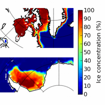
Level 2 PMW sea ice concentration
Operational Near real time productSea ice concentration product on satellite swath for SSMIS and AMSR-2 instruments. The product is delivered on the native spatial sampling, and with separate product files for SSMIS and AMSR-2. The product also includes uncertainty estimates and product quality flags. For both SSMIS and AMSR-2 the low frequency channels (19V, 37H and 37V) are used. For the AMSR-2 also the two high frequency channels (89H and 89V) are used.
Identification
Acronym : L2 SICO
Product navigator reference :
EO:EUM:DAT:0401
OSI SAF producer : Danish Meteorological Institute
Identifier : OSI-410-a
Acronym for EDC (APNM) : OSICOL2
License/Attribution : See at bottom
Characteristics
Processing level : L2
Satellite input : DMSP/SSMIS, GCOM-W1/AMSR-2
Other input : NWP outputs
Temporal sampling : Up to 15 per day for each SSMIS, and up to 15 per day for AMSR-2
Central time : NA
Timeliness :
?
The timeliness is the time elapsing from the sensing time of the last contributing file to the product dissemination to users. It is similar to the latency.
3h40
Spatial coverage : Global
Spatial sampling : SSMIS: 25 km, AMSR-2: 10 km
Projection : Swath
File Formats : HL FTP Server (NetCDF4), EDC (NetCDF4), EUMETCast (NetCDF4)
Characteristics & methods : L2 fractional ice cover in percentage.
Data Access
OSI SAF FTP server (last 31 days)
ftp://osisaf.met.no/prod/
Directories: ice/conc_l2_amsr/, ice/conc_l2_ssmis/
OSI SAF FTP server (archive)
ftp://osisaf.met.no/archive/
Directories: ice/conc_l2_amsr/, ice/conc_l2_ssmis/
OSI SAF Thredds
EUMETSAT Multicast
Accuracy Requirements
Target accuracy : 10 % for NH-product. 15 % for SH-product
Verification/validation method : Comparison with high resolution manual ice charts (Frequency of availability between once a day and once a week): the performance shall be validated for only the “ice” (100 % ice) and “water” (0 % ice) cases, separately.
Applications and users
Usage : NWP and Ocean/Ice models, operational Met and Sea Ice services.
History
Authorised to be operational / released :
Declared operational / released since :
On EUMETCast since :
On EDC since :
On FTP server since :
First date :
Full series temporal coverage : 2021-onwards
Detailed history :
The product series is operational since 2021:
- version OSI-410 from 01/07/2021 to 21/01/2023
- version OSI-410-a from 21/01/2023 onwards
License/Attribution
License/Attribution : OSI SAF Level 2 PMW sea ice concentration, OSI-410-a. EUMETSAT Ocean and Sea Ice Satellite Application Facility. Data extracted from [distributor/distribution mean]: ([extracted period],) ([extracted domains],) accessed [download date]
The content within square brackets "[…]" is to be replaced with whatever distributor, period, domain or download date is relevant to the data being used. The "extracted period" and "extracted domains" are only needed if a subset of the data is being used.
Suggestions for "distributor/distribution mean": OSI SAF FTP server/the EUMETSAT Data Centre/EUMETCast/name and URL of a redistributor...
Comments
New ticket helpdesk


Until 18/10/2024, the difference in frequency between SSMIS and AMSR-2 is due to the recipient of input data. SSMIS is received per orbit from EUMETCast while AMSR-2 is received per half-orbit from JAXA. This means that there are up to 75 files per day, one for each orbit and each of the three SSMIS satellites and two for each orbit and the AMSR satellite.
From 18/10/2024, AMSR-2 L2 PMW sea ice concentration is disseminated as full orbit files (not half-orbits anymore), like the SSMIS files. This means that there are up to 60 files per day.