
 Licensed under CC BY 4.0 by EUMETSAT
Level 2 PMW Sea-Ice Concentration
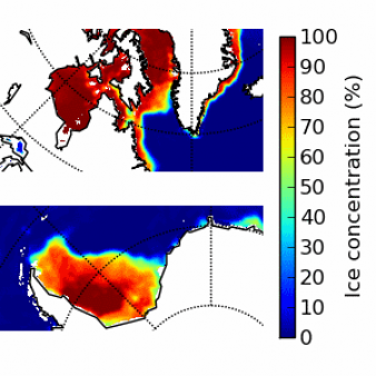
Operational Near real time productSea ice concentration product on satellite swath for the AMSR3 instrument. The product is delivered on the native spatial sampling. The product also includes uncertainty estimates and product quality flags. The low frequency channels (19V, 37H and 37V) and the two high frequency channels (89H and 89V) are used.
Identification
Acronym : L2 SICO
EUMETSAT collection ref. :
EO:EUM:DAT:0401
OSI SAF producer : Danish Meteorological Institute
Identifier : OSI-410-g
Id for archive (APNM) : OSICOL2
Characteristics
Processing level : L2
Satellite input : DMSP/SSMIS, GOSAT-GW/AMSR3
Other input : NWP outputs
Temporal sampling : Up to 15 per day for each SSMIS, up to 15 per day for AMSR3
Central time : NA
Timeliness :
?
The timeliness is the time elapsing from the sensing time of the last contributing file to the product dissemination to users. It is similar to the latency.
3h40
Spatial coverage : Global
Spatial sampling : SSMIS: 25 km, AMSR3: 10 km
Projection : Swath
File Format(s) : NetCDF4
Characteristics & methods : L2 fractional ice cover in percentage.
Data Access
OSI SAF FTP server (last 31 days)
ftp://osisaf.met.no/prod/
Directories: ice/conc_l2_amsr/, ice/conc_l2_ssmis/
OSI SAF FTP server (archive)
ftp://osisaf.met.no/archive/
Directories: ice/conc_l2_amsr/, ice/conc_l2_ssmis/
OSI SAF Thredds
EUMETSAT Multicast
Accuracy Requirements
Target accuracy : 10 % for NH-product. 15 % for SH-product
Verification/validation method : Comparison with high resolution manual ice charts (Frequency of availability between once a day and once a week): the performance shall be validated for only the “ice” (100 % ice) and “water” (0 % ice) cases, separately.
Applications and users
Usage : NWP and Ocean/Ice models, operational Met and Sea Ice services.
History
Authorised to be operational / released :
Declared operational / released since :
On EUMETCast since :
On FTP server since :
First date :
Full series temporal coverage : 2021-onwards
Detailed history :
The product series is operational since 2021:
- version OSI-410 from 01/07/2021 to 21/01/2023
- version OSI-410-a from 21/01/2023 (with SSMIS, AMSR2 as inputs)
- version OSI-410-g from 01/09/2026 (with SSMIS, AMSR3 as inputs)
Licence/Attribution/Citation
Licence : CC BY 4.0
Attribution : You must include attribution to EUMETSAT OSI SAF
Recommended citation : EUMETSAT OSI SAF, Level 2 PMW sea ice concentration (2026), OSI-410-g
Comments
New ticket helpdesk
See the page Implications of AMSR2 being replaced by AMSR3 on OSI SAF products
The land mask for AMSR3 products is a bit less restrictive compared to the AMSR2 or SSMIS products in order to provide a better coverage e.g. inside fjords.
If you haven't yet, consider subscribing to our service message for Sea Ice: https://osi-saf.eumetsat.int/community/list-of-service-messages.