09/06/2022
OSI SAF at ESA Living Planet Symposium 22 and EGU General Assembly 2022
-
Spring is marked by several scientific conferences in the field of Earth Observation in Europe. Gathering international experts from across the world the European Space Agency (ESA) Living Planet Symposium and the European Geoscience Union (EGU) General Assembly are two main events marking the season. OSI SAF work was presented at both conferences.
The European Space Agency’s 2022 Living Planet Symposium, which is held every three years, took place on 23–27 May 2022 in Bonn, Germany. The EGU General Assembly 2022 which is held every year took place the same week in Vienna. Attracting thousands of scientists and data users, ESA’s Living Planet Symposia are amongst the biggest Earth observation conferences in the world. The EGU General Assembly on the other hand is the biggest Geoscience conference annually held in Europe.
You did not have the chance to attend ? This story gives you access to some of the content presented and provides key take home points from our experts.
-
Sea Surface Winds
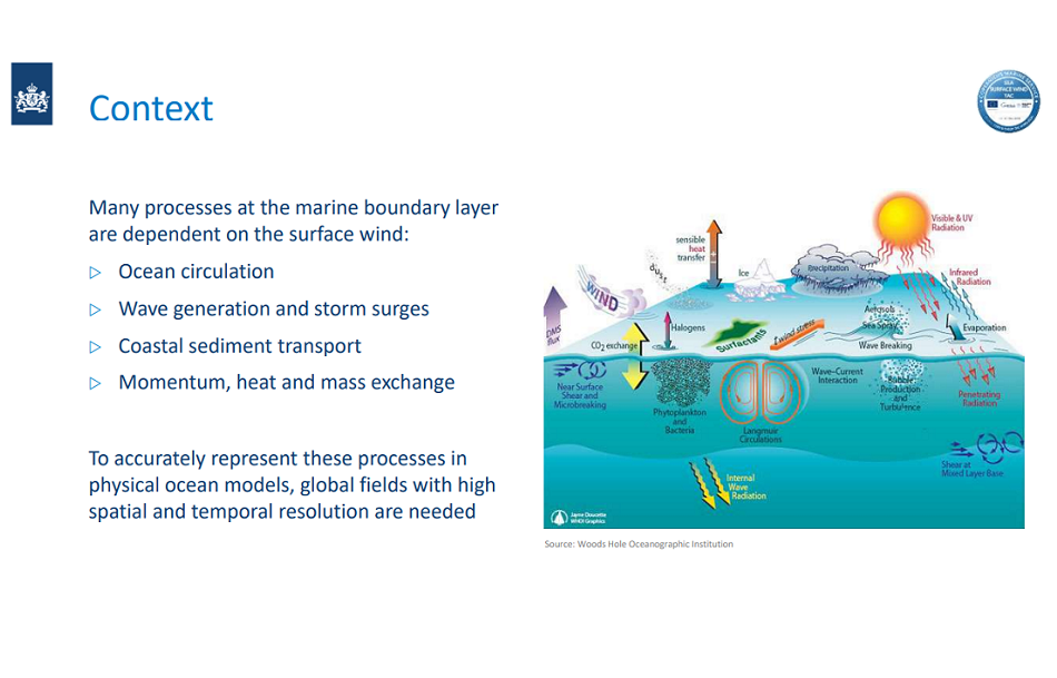
OSI SAF colleagues at the Royal Netherlands Meteorological Institute (KNMI) are working on Sea Surface Winds. From improving the retrieval algorithms at Level 2 up to integrating stress-equivalent wind into Level 4 Copernicus Marine global products, KNMI colleagues work on several aspects of Sea Surface Winds. Zhen Li and Ad Stoffelen participated to ESA Living Planet Symposium in Bonn. Rianne Giesen participated to EGU General Assembly in Vienna.
Poster: Improvement of the Ku-band Winds in Rainy Regions Obtained by a Support Vector Machine Method
Dr. Xingou Xu | NSSC, CAS | China
Dr. Ad Stoffelen | The Royal Netherlands Meteorological Institute (KNMI) | NetherlandsAd Stoffelen presented a poster of common work with a chinese colleague Xingou Xu et al. about using machine learning to correct rain-contaminated Ku-band scatterometer winds. In addition, this work attempted to determine rain rate over a scatterometer wind vector cell, exploiting the Ku-band NRCS and wind retrieval information, and achieved some success.
This poster is available here.
Presentation: forthcoming Copernicus Marine Service L4 gridded wind product - A high-resolution ocean wind forcing product for the Copernicus Marine Service
Dr. Rianne Giesen | Royal Netherlands Meteorological Institute (KNMI) | Netherlands
Dr. Ad Stoffelen | Royal Netherlands Meteorological Institute (KNMI)
Ana Trindade | Institut de Ciències del Mar, CSIC
Dr. Marcos Portabella | Institut de Ciències del Mar, CSICRianne Giesen presented the forthcoming Copernicus Marine Service L4 gridded wind product at the EGU, while Ad Stoffelen presented it at the ESA Living Planet Symposium. It will be released in July and contains hourly wind vectors, wind stress and their spatial derivatives, i.e., curl and divergence. It is based on the L2 swath products of the same variables that are derived from the OSI SAF winds. These products could offer convenient access to information for the users compared to L2, since they are hourly and gridded. Exploiting the OSI SAF L2 scatterometer winds, in particular mesoscale variability and spatial derivatives are enhanced with respect to other global gridded products. In addition, persistent ECMWF model biases are repaired in the L4 wind and stress products. Users are welcome to use these products in their applications and provide feedback on their content, usefulness and impact.
The full presentation is available here.
-
Interview for German Radio: "Was vom All aus vom Klimawandel zu beobachten ist ?"
Ad Stoffelen shared a few words on the importance of measuring extreme winds in a changing climate on German Radio. The recording of the interview conducted by Guido Meyer is available here.
-
Sea Ice Parameters
OSI SAF from the Meteorological Institutes from Danemark and Norway, together form the OSI SAF high latitude processing center gathering expertise on processing of Sea Ice Parameters. Thomas Lavergne and Emily Jane Down from the Norwegian Meteorological Institute, MET Norway, attended ESA Living Planet symposium.
Poster: Sea Ice Drift from Satellite Passive Microwave Missions : from Climate Monitoring to CIMR
Emily Jane Down | Norwegian Meteorological Institute | Norway
Thomas Lavergne | Norwegian Meteorological Institute | NorwayEmily Down presented a poster about Sea Ice Drift from satellite passive Microwave Missions. Sea ice drift is a key variable for understanding sea ice in a changing climat. In the Arctic, sea ice has been reported to drift faster, concomitant with its reduction in area, general thinning, and loss of multiyear ice. In the Antarctic, trends in sea ice drift have been linked to trends in wind patterns. A new global 30-year Climate Data Record (CDR) of sea ice drift vectors from 1991 to 2020 was presented. It uses the continuous maximum cross-correlation technique (CMCC) for measuring sea ice drift, by matching features in a pair of satellite images. Additionally this poster presents the results of an investigation into calculating sea ice drift vectors from pairs of individual swaths of PMW missions rather than from daily gridded satellite imagery, today’s status-quo. A study undertaken in preparation for the Copernicus expansion mission Copernicus Imaging Microwave Radiometer (CIMR).
This poster is available here.
-
As a comment on my participation, I am still fairly new to the earth observation field, so I really enjoyed attending sessions on satellites and instrumentation, and on the cryosphere, to get a better overview. The poster session was great to connect with interested people, some of who were keen to use the products in their work or shared ideas on future directions. Emily
-
Poster: Bayesian Sea Ice Detection algorithm for CFOSAT
Dr. Zhen Li | Royal Netherlands Meteorological Institute (KNMI) | Netherlands
Dr. Anton Verhoef | Royal Netherlands Meteorological Institute (KNMI) | Netherlands
Dr. Ad Stoffelen | Royal Netherlands Meteorological Institute (KNMI) | NetherlandsZhen Li presented work on the development of and adapted Bayesian sea ice detection model that is incidence angle-dependent, and also takes the diverse geometry across the swath into account. The unique feature of the scatterometer from CFO SAT, CSCAT, is the rotating fan-beam, and it leads to a very diverse geometry across the swath, which the current Bayesian sea ice model for pencil-beam and fixed fan-beam scatterometers cannot fulfill the condition. The result is validated with ASCAT data and gives satisfying outcome. Additional validation with passive microwave instrument was also presented at the symposium.
This poster is available here.
Poster: Mapping sea ice type with satellite passive microwave and scatterometer missions - from near-real-time conditions to climate scale
Dr. Signe Aaboe | Norwegian Meteorological Institute | Norway
Emily Jane Down | Norwegian Meteorological Institute | Norway
Steinar Eastwood | Norwegian Meteorological Institute | Norway
Thomas Lavergne | Norwegian Meteorological Institute | Norway
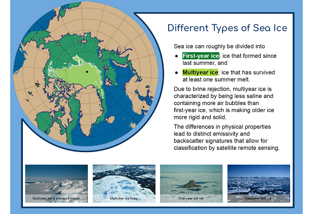
Atle M. Sørensen | Norwegian Meteorological Institute | NorwayA poster about Sea Ice Type was also created by Signe Aaboe and presented by Emily Down. Sea ice can roughly be divided into seasonal (or first-year) ice that formed since last summer, and multiyear ice that has survived at least one summer melt. Due to brine rejection, multiyear ice is characterized by containing more air bubbles and much less salt than first-year ice, which is making older ice more rigid and solid. In addition to changing the physical properties, these differences lead to distinct emissivity and backscatter signatures that allow classification by satellite remote sensing. More than four decades of satellite monitoring of the Arctic shows that the sea ice has reduced significantly in extent and is becoming rapidly younger, going towards a more seasonal ice cover.
-
 Different Sea Ice Types
The EUMETSAT Ocean and Sea Ice Satellite Application Facility (OSI SAF) has since 2005 been monitoring the Arctic sea ice type on a daily basis. And since 2021, a classification of the Southern Hemisphere ice type has been implemented as well. For the computations are used both passive microwave radiometer (SSMIS, AMSR-2) and scatterometer (ASCAT) data, providing the ice type product on a 25x25 km grid spacing. Within the EU Copernicus Climate Change Service (C3S), the long series of subsequent passive microwave radiometers (SMMR, SSM/I, SSMIS) going back to 1978, is utilized to compute a climate consistent data record of Arctic sea-ice type. -
In this contribution, the new Southern Hemisphere sea-ice type product which can be relevant for the expansion Copernicus Imaging Microwave Radiometer mission (CIMR) is presented. The 40+ years of Arctic sea-ice type record from C3S is also introduced. The general algorithm baseline is described and validation against other sea-ice classification products is shown.
This poster is available here.
Poster: Version 3 of the ESA CCI and EUMETSAT OSI SAF Sea Ice Concentration Climate Data Records
Thomas Lavergne | Norwegian Meteorological Institute | Norway
Atle M. Sørensen | Norwegian Meteorological Institute | Norway
Dr. Rasmus Tage Tonboe | Technical University of Denmark
Roberto Saldo | Technical University of Denmark
Leif Toudal Pedersen | Technical University of Denmark
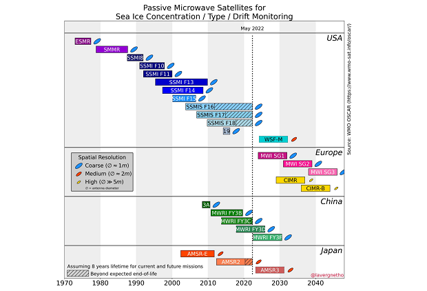
Matilde Brandt Kreiner | Danish Meteorological InstituteThe now 43-years long time-series of sea-ice extent (SIE) and area (SIA) are headline indicators of climate change. The interested public follows their seasonal evolution and potential record low and high values on online trackers, and climate scientists benchmark their model against them. The climate indicators are based on a multi-mission data record of sea-ice concentration (SIC), itself derived from brightness temperature measurements by passive microwave missions since the 1970s.
-
 SIC CDR
Over the past few years, we conducted a coordinated R&D effort from the EUMETSAT Ocean and Sea Ice Satellite Application Facility (OSI SAF) and the ESA Climate Change Initiative (CCI) programme. It has resulted in a collection of state-of-the-art sea-ice concentration climate data records, and their operational extensions (Lavergne et al., 2019). Version 2 of these data, released in 2017, was successfully transferred to the Copernicus Marine (CMEMS) and Climate Change Service (C3S), informed the IPCC Assessment Report 6 Working Group 1 report, and were used in the C3S reanalyses.
-
In this contribution, the latest version of these SIC CDRs, Version 3, is introduced with a particular focus on the temporal consistency aspects across the different satellite missions from the 1970s to present.
This poster is available here.
-
A general comment on my participation is that it was useful to reconnect with the scientific community, ESA, and ECMWF. With climate monitoring in mind, it was particularly interesting to interact with GCOS at the time where they are finalizing their new Implementation Plan (IP-22). In this context it was useful to contribute to a panel discussion led by GCOS together with ESA and C3S. Thomas


