07/02/2023
Generating a snow and ice thickness dataset from space-borne freeboard measurements for evaluating the sensitivity of the snow microwave radiative transfer model (SMRT)
-
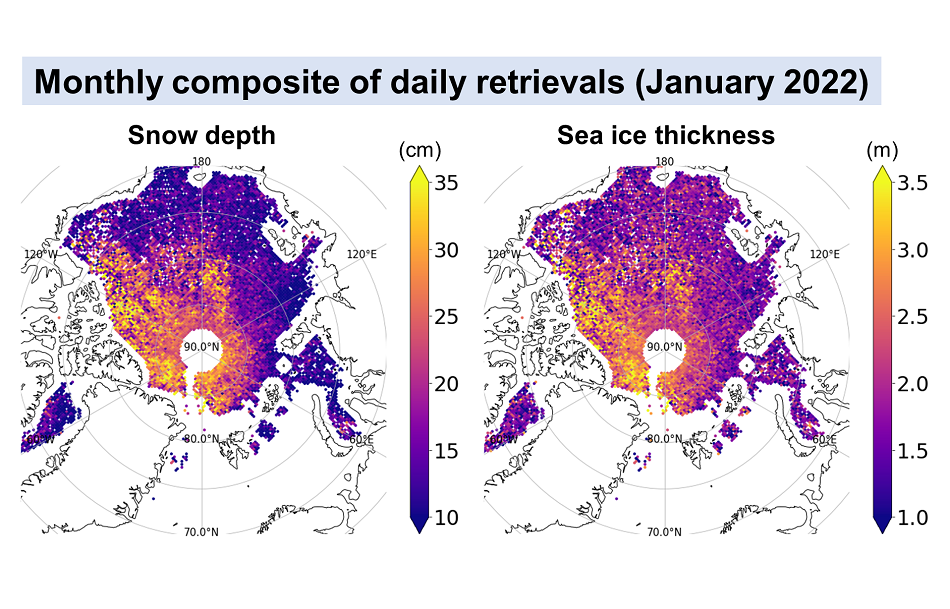
In the context of the OSI SAF Visiting Scientist Activities Program, Hoyeon Shi from Seoul National University (SNU) in South Korea, worked on generating Arctic snow depth and sea ice thickness dataset by combining CryoSat-2, AMSR, and AVHRR measurements. This work was done in 2022/2023 and was supervised by Gorm Dybkjær (DMI), Fabrizio Baordo (DMI), Suman Singha (DMI), and Byung-Ju Sohn (SNU).
-
Objectives framework of the study
The main objective was to produce a daily snow depth and sea ice thickness dataset from satellite measurements to support the evaluation of the Snow Microwave Radiative Transfer model (SMRT). To evaluate the performance of SMRT, realistic input data of snow and sea ice properties are essential for simulating brightness temperature (TB) that would be observed from satellite sensors.
Based on a method developed by Satellite Meteorology Laboratory at Seoul National University in collaboration with DMI (Shi et al., 2020) with the updated sea ice density parametrization (Shi et al, 2023), snow depth and sea ice thickness were estimated from CryoSat-2 radar freeboard (AWI dataset v2p4), AVHRR snow surface temperature (Copernicus CMEMS level 4 product), and AMSR snow-ice interface temperature (Lee and Sohn, 2015). The key concept of this method is using the ratio of snow depth to sea ice thickness (hereafter referred to as α), which can be estimated from the snow surface and snow-ice interface temperatures, to convert radar freeboard into snow depth and sea ice thickness simultaneously.
To produce a dataset with enhanced quality, two updates for the estimation method were made during this project:
- First, the period of retrieval was shortened from a month to a day. To do so, coefficients in the α-prediction equation (Shi et al., 2020) were newly found for daily time-scale by analyzing buoy-measured snow-ice temperature profiles.
- Second, potential systematic bias in the radar freeboard was considered. The radar freeboard dataset may have its own bias, which is difficult to be corrected explicitly; therefore, this project found an empirical relationship converting radar freeboard into total freeboard as a function of snow depth by relating CryoSat-2 radar freeboard to the total freeboard obtained from NASA’s Operation IceBridge (OIB) mission.
-
Report conclusions
The two updates on the α-prediction equation and the freeboard conversion (or correction) method were successfully implemented on the existing retrieval method. Based on the updated retrieval method, the daily snow depth and sea ice thickness dataset was produced for the 2011–2022 period from January to March, using CryoSat-2, AVHRR, and AMSR data.
To validate the produced dataset, the retrieved snow depth and sea ice thickness were compared against the OIB dataset and the upward-looking sonar measurements of the Beaufort Gyre Exploration Project’s mooring observation :
- The comparison showed that there was good consistency between the retrievals and the validation datasets.
- The implementation of the new radar freeboard correction method resulted in a reduction in RMSE compared to the validation datasets.
- In addition, the retrieved sea ice thickness showed good consistency with C3S and PIOMAS sea ice thickness datasets.
-
Benefits for the OSI SAF
- The snow depth and sea ice thickness produced by this project will be useful for SMRT simulation because it is difficult to obtain snow and sea ice properties that are spatially large-scale and temporally frequent from in situ measurements.
- Comparing satellite-observed TB and SMRT-simulated TB with input data from this project will provide a good opportunity to assess the performance and sensitivity of SMRT. This is an essential part of the observation operator work in CDOP4 of the OSISAF.
- It will be beneficial to performe the snow and sea ice thickness retrieval based on ICESat using the developed method. The Inclusion of ICESat will extend the data record back to 2003, which is valuable for securing more input datasets for the SMRT simulation.
-
Report on this study
-
Authors
Hoyeon Shi and Byung-Ju Sohn from Seoul National University (SNU) in South Korea
Gorm Dybkjær, Fabrizio Baordo and Suman Singha from the Danish Meteorological Institute (DMI)
-
References
- Lee S.-M. and B.-J. Sohn (2015): Retrieving the refractive index, emissivity, and surface temperature of polar sea ice from 6.9 GHz microwave measurements: A theoretical development, J. Geophys. Res. Atmos., 120(6), 2293–2305, doi: 10.1002/2014JD022481.
- Shi, H., B.-J. Sohn, G. Dybkjær, R. T. Tonboe, and S.-M. Lee (2020): Simultaneous estimation of wintertime sea ice thickness and snow depth from space-borne freeboard measurements, Cryosphere, 14(11), 3761–3783, doi: 10.5194/tc-14-3761-2020.
- Shi, H., S.-M. Lee, B.-J. Sohn, A. J. Gasiewski, W. N. Meier, G. Dybkjær, and S.-W. Kim (2023): Estimation of winter snow depth, sea ice thickness and density, and ice freeboard by combining CryoSat-2, AVHRR, and AMSR measurements (manuscript in revision for IEEE Trans. Geophys. Remote Sens.)

