17/01/2018
Correlating extremes in wind and stress divergence with extremes in rain over the Tropical Atlantic
-
In the context of the OSI SAF Visiting Scientist Program, Gregory King worked from the Institut de Ciències del Mar (ICM - CSIC) in Barcelona, Spain on Correlating extremes in wind and stress divergence with extremes in rain over the Tropical Atlantic. This work took place in 2016 - 2017 and was supervised by Marcos Portabella (ICM) and Ad Stoffelen (KNMI).
Objectives and framework of the study :
Relevant rain-induced dynamics near moist convection in the tropics are not resolved by General Circulation Models (GCMs) and the parameterization of its effects is poor. This poses a limitation to the understanding of tropical circulation in particular.
In this study, wind fields from the ASCAT-A and -B tandem mission were collocated with a time series of Meteosat Second Generation rain fields (KNMI) at a 15-min interval. These were used to quantify correlations and lags of heavy/extreme rain with extremes in small-scale wind convergence/divergence.
The objective was to improve understanding of moist convection and its implications for climate circulation and of convective parameterizations in GCMs.
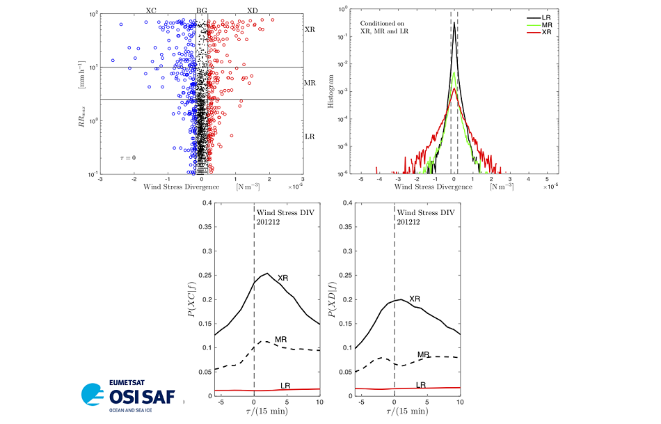
Report conclusion : The top left panel in the figure shows a scattergram of local extreme values in wind stress divergence against maximum rainfall intensity occurring within the same vicinity (a 25km-by-25km neighbourhood) from a typical ASCAT pass across the Inter-Tropical Convergence Zone. Using probability distributions of convergence/divergence and of rainfall intensity, thresholds were identified and used to classify extreme and background events in each dataset. The thresholds are drawn as vertical and horizontal lines on the scattergram and event acronyms are given across the top and right-hand sides. The three divergence categories are: extreme convergence (XC, blue circles), background (BG, black dots), and extreme divergence (XD, red circles), and the three rain rate categories are: light rain (LR), medium rain (MR), and extreme rain (XR). The top right panel shows log-probability distributions conditioned on the rain categories (one month of observations).
The coincidences were tabulated in contingency tables from which cross-correlations were calculated for each time step in the collocation. The resulting response curves for extreme convergence (bottom left panel) and extreme divergence (bottom right panel) each have a well-defined peak. The time lag for the convergence peak was about 30 minutes, implying that extreme rain generally appears after (lags) extreme convergence.
The overall conclusions is that :
- when there is extreme rain, there is extreme convergence/divergence in the vicinity, and
- the temporal scale of moist convection is determined by the slower updraft process.
Results for wind and wind stress divergence were qualitatively similar, wind stress divergence showing the stronger response. This is probably due to the fact that the wind stress depends on (at least) the square of the wind, leading to larger tails in the distribution of the stress divergence. It was also found that extreme convergence/divergence are concentrated in spatial patches.
Benefits for the SAF :
- Visibility of the OSI SAF wind products in the international scientific community in the relevant application areas of climate processes and GCM development;
- Development of wind product requirements for these application areas;
- Synergistic application of its products with other EUMETSAT sensor products;
- Improved understanding of scatterometer winds near moist convection.
Report on this study : Correlating extremes in wind and stress divergence with extremes in rain over the Tropical Atlantic

