
19/03/2026
EUMETSAT OSI SAF iceberg climate products
-
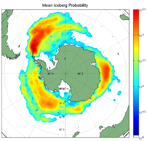
OSI SAF is taking on board the development and operations of the Altiberg product to make a climate product from 1992 to today. The Iceberg from Altimetry CDR/ICDR (OSI-490 and OSI-480), a version 4 of the previously called Altiberg, is a Level-3 gridded distribution, area and volume of small icebergs. It contains iceberg probability, ice volume, mean iceberg area, lat/lon, number of individual detections per altimeter, standard deviation of estimated volume, iceberg area probability density function (PDF) by all available altimeters, over Southern Ocean and Arctic.
-
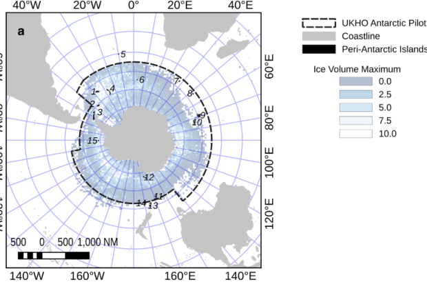 Iceberg volume and extent database, from altimeters (Tournadre and others, 2021)
Image from:
Headland RK, Hughes NE, Wilkinson JP. Historical occurrence of Antarctic icebergs within mercantile shipping routes and the exceptional events of the 1890s. Journal of Glaciology. 2023;69(278):2046-2058. doi:10.1017/jog.2023.80
-
Contrary to large tabular icebergs that are routinely tracked and monitored using scatterometer, Synthetic Aperture Radars (SAR) or optical data, the distribution of smaller icebergs, i.e. less than 2-3 km in length, in the Southern Ocean is known mainly from ship-based observations with a limited temporal and spatial coverage. Indeed, they are difficult to detect operationally using satellite sensors. Sensors using the visible and infrared sprectrum are often blinded by clouds whilst low resolution passive microwave sensors cannot detect such small features. Microwave scatterometer have been used regionally and with limitations to establish statistics on icebergs in coastal areas. Even if SAR detecting capabilities have been demonstrated, these instruments are not yet used on operational basis for iceberg distribution, mainly due to the large amount of data to be processed.
Jean Tournadre and his team (see links at bottom) have demonstrated that small icebergs, at least in open water, have a significant signature in the noise part of altimeter waveforms and that the analysis of altimeter waveforms enables to determine the small icebergs distribution on a monthly basis, or even 2-weekly in the latest years (with more altimeters flying). The method they proposed also allows to estimate, under assumptions on the free-board height and on the ice backscatter, the iceberg surface and thus the ice volume.
The Altiberg v3.1 product, released by Ifremer, is a description of the small iceberg (100m-3km) distribution on the period 1992-2023. The iceberg size, which follows a log-normal distribution with an overall mean length of 630 m, has a strong seasonal cycle reflecting the melting of icebergs during the austral summer estimated at 1.5 m/day.
Here are some characteristics of the products under development:
Projection
Spatial sampling
Temporal sampling
Temporal coverage
Comments
polar-stereographic
100 km for Antarctic
50 km for Arcticmonthly
1992-onwards
Contrary to Antarctic, 50 km resolution is achievable in Arctic from 1992
250 km
monthly
1992-onwards
Iceberg area probability density function (PDF) distribution is provided only at this spatial resolution.
50 km
2-weekly
2010-onwards
2-weekly only achievable starting from 2010
cylindrical equidistant (lat/lon grid)
1°x2° (about 100km wide cells)
monthly
1992-onwards
2-weekly
2010-onwards
2-weekly only achievable starting from 2010
-
And next ?
The first product is planned to be released in 2026 and will use all past and present altimeters waveforms since 1991 from Sentinel-3A & B & C & D, Saral, HY2A, HY2B, HY2C, Jason-1, Jason-2, Jason-3, Sentinel-6A, CryoSat, Topex, Poseidon, Envisat, ERS-1, ERS-2, GeoSat, CFOSAT, SWOT from the Sensor and Geophysical Data Record (SGDR, equivalent to Level 1) products.
In the coming years, OSI SAF has committed to add the altimeter waveforms from Sentinel-6B and Sentinel-3C when they are available. Later, the Sentinel-3D and Cristal altimeter waveforms will also be added to extend this climate product.
Iceberg from Altimetry - Level-3 gridded distribution, area and volume of small icebergs Time period Sources Planned release OSI-490 CDR 1992-2025 Altimeter waveforms (SAR and LRM or PLRM mode) since 1991 from Sentinel-3A & B & C & D, Saral, HY-2A, HY-2B, HY-2C, Jason-1, Jason-2, Jason-3, Sentinel-6A, CryoSat, Topex, Poseidon, Envisat, ERS-1, ERS-2, GeoSat, CFOSAT, SWOT from the Sensor and Geophysical Data Record (SGDR, equivalent to Level 1) products. SGDR input data are usually available several days or weeks after acquisition, making them suitable for CDR processing but not for ICDR. 2026 OSI-480 ICDR 2026-onwards Altimeter waveforms (SAR and LRM or PLRM mode) from Sentinel-3A & B & C & D, Saral, HY-2C, HY-2D, Jason-3, CryoSat-2, Sentinel-6A, SWOT from Intermediate Sensor and Geophysical Data Record (SIGDR, equivalent to Level 1) products. SIGDR input data are usually available within 3 days after acquisition allowing for more frequent update of the time serie. 2026 OSI-480-a ICDR 2026-onwards Sources of OSI-480 + Sentinel-6B and Sentinel-3C data >=2027 OSI-480-b ICDR 2026-onwards Sources of OSI-480-a + Cristal data >=2030 Interest in icebergs has been growing in recent years as they may account for a signi cant part of the freshwater flux in the Southern Ocean and because they have been shown to transport nutriments (in particular labile iron) that could have a significant impact on ocean primary productivity. It was also demonstrated that small iceberg can have a significant impact on sea state modeling.
-
-
Document on the first Altiberg product:
Document on the latest available Altiberg product: